 Vista

Need plate tectonics, earthquake and tsunami school project pictures? This guide includes three distinct diagrams: a Tectonic Plate Model, an Earthquake-Resistant Building Concept and Tsunami Formation. Students in approximately Classes 6–12 can use them to explain how Earth’s rigid outer shell is divided into moving plates, how stress may be released in earthquakes and how sudden seafloor movement can create dangerous ocean waves. Each picture can be viewed or saved full-size, with materials, project steps, classroom questions and safety notes below. A cardboard building or sea-wave model is an educational representation, not a certified design that can predict or guarantee real-world protection.
How are tectonic plates, earthquakes and tsunamis connected?
Earth’s lithosphere is divided into large and small tectonic plates that move slowly. Stress may accumulate along faults, and sudden slip releases seismic energy that produces shaking. Many earthquakes occur near plate boundaries, but earthquakes can occur away from them as well. Some sufficiently large undersea earthquakes move the seafloor vertically, displacing water and generating a tsunami. Not all earthquakes produce tsunamis, and not every tsunami has the same source. Keeping these three diagrams separate helps students understand the relationships without assuming they are identical events or that each plate movement creates an ocean disaster.
Picture 1: Plate Tectonics Model
Three commonly taught boundary types are convergent, divergent and transform. Convergent plates move toward one another; divergent plates move apart; transform boundaries involve plates sliding alongside one another. These different motions relate to distinct geological settings, but the results are not identical at every boundary. Mark plate edges and arrows carefully. Avoid teaching that every collision causes an immediate eruption or that tectonic plates travel quickly like toy cars. Cardboard pieces can slide slowly past one another to demonstrate relative motion. A flat school poster is simplified and cannot capture the full structure of Earth’s mantle or crust.
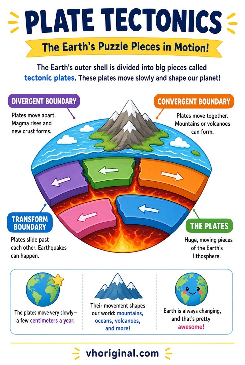
Chart note: Use the text labels rather than the central arrows. Divergent arrows point apart, convergent arrows point toward each other, and transform arrows run in opposite directions along the boundary.
Picture 2: Earthquake-Resistant Building Concept
Seismic shaking creates forces that a real building must be designed to withstand. Engineering solutions consider materials, ductility, connections, structural layout, site conditions and applicable building standards. A cardboard classroom frame with diagonal bracing may help compare one structural concept, but it cannot certify a real building as earthquake-proof. No single brace guarantees safety in every possible earthquake. Use small lightweight paper buildings for demonstrations and keep heavy objects away from children. Actual construction, renovation or seismic retrofitting requires qualified engineers and local code compliance. Tell students the difference between a concept model and a tested structure.
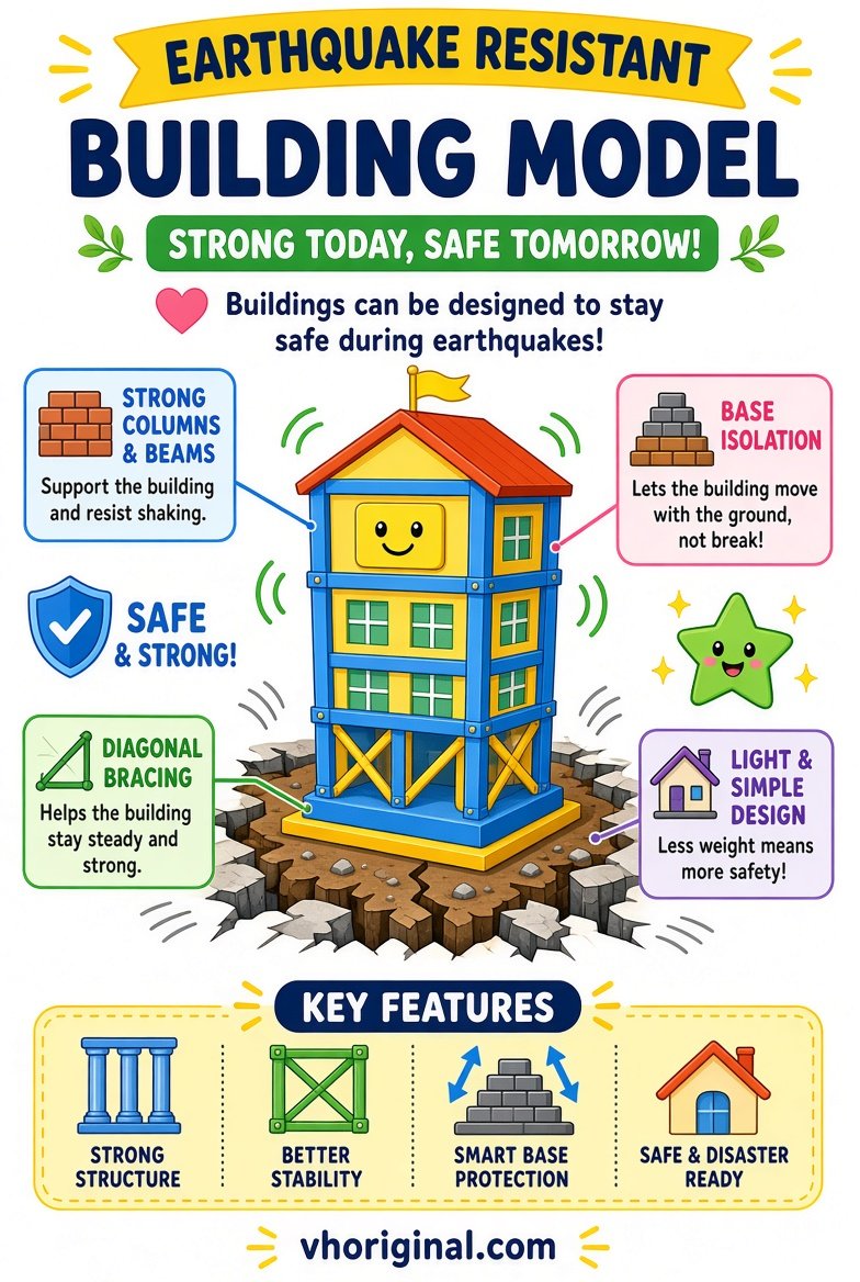
Chart note: The classroom model illustrates bracing and base isolation. It does not verify the safety of a real building in an earthquake.
Picture 3: Tsunami Formation Diagram
Tsunamis can result when a large volume of ocean water is suddenly displaced, often by a major undersea earthquake with significant vertical seafloor movement. Some landslides and volcanic events may also generate tsunamis. A tsunami is not simply a normal ocean tide or a single giant surfing wave. Its appearance changes as waves move from deep water toward shallow coastal areas. Label seafloor displacement, water movement, propagation and shoreline impacts in order. A diagram cannot predict the size or arrival time of a real tsunami at a specific coast. Avoid invented wave heights or claims that every offshore earthquake produces one.
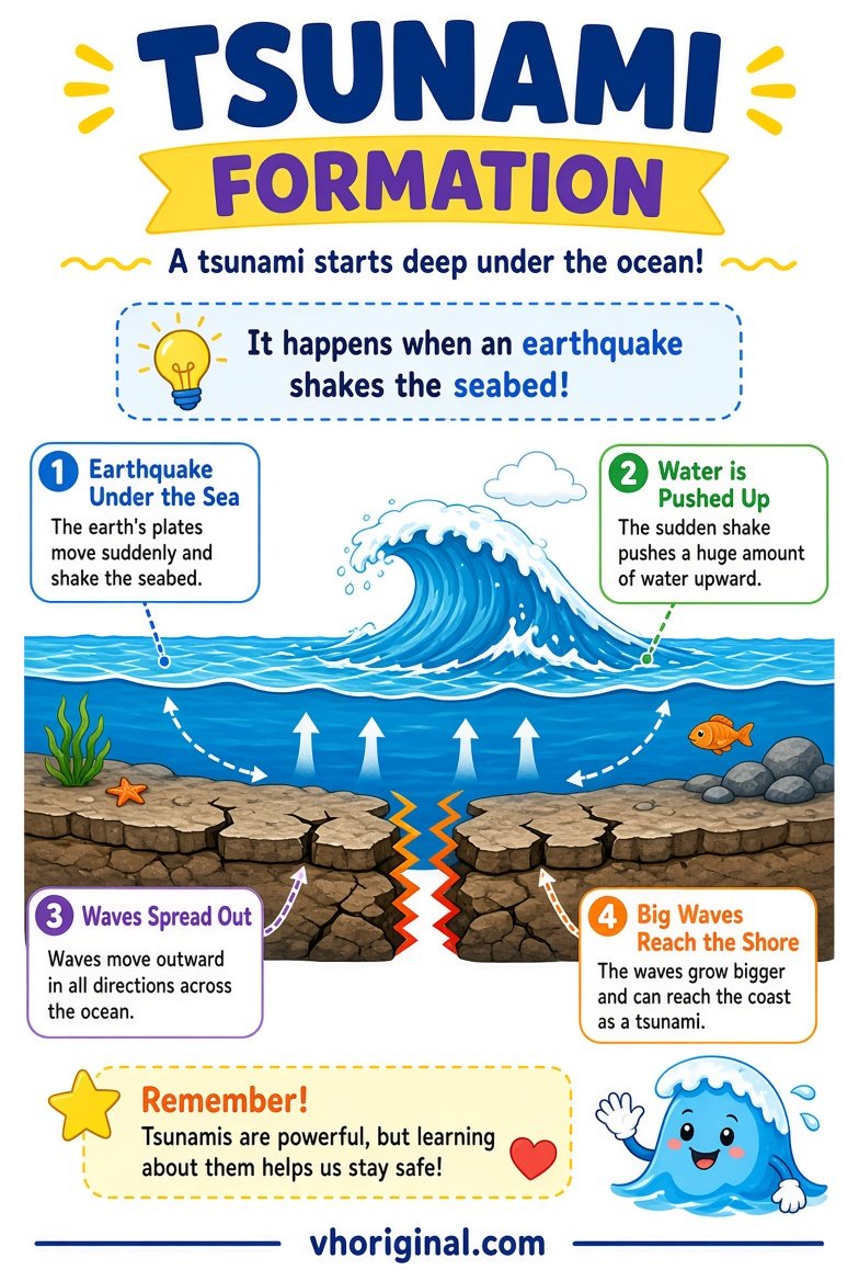
Chart note: A common trigger is sudden vertical movement of the seabed. Many undersea earthquakes do not cause tsunamis. Landslides and volcanic activity can also trigger them.
Materials for a safe Earth Science display
A firm cardboard base, coloured paper, pencil, ruler, safe glue and lightweight cut-outs are enough for all three pictures. Use movable paper blocks for plate boundaries, a small braced paper frame for the building concept and a blue paper water layer for the tsunami diagram. Real electricity, powerful moving machinery or aggressive shaking are unnecessary. If a teacher specifically requests a water demonstration, keep it small, stable and supervised, away from electrical equipment and slippery floors. Give every model its own name and clearly labelled arrows. Simpler constructions help pupils explain the process rather than merely admire the display.
Step-by-step: draw and explain each diagram
First open the relevant full-size image and choose essential parts. Sketch the plate boundaries and motion arrows. In the building picture, mark structural components without labelling it guaranteed safe. For tsunami formation, separate the seabed change, water displacement and wave travel into a clear sequence. Colour only after checking arrows against school references. Place one or two sentences beneath each panel describing the process and a limitation. Do not force all three full posters onto one tiny A4 page if labels become illegible. Finally ask students to explain why the three processes are linked but not interchangeable.
Earthquake and tsunami safety in real life
Real disaster safety requires official advice, not the cardboard model. During strong shaking indoors, guidance such as Drop, Cover and Hold On is widely recommended where appropriate. Avoid windows and falling objects. In coastal tsunami-risk areas, strong or prolonged shaking can be a natural warning: follow local emergency instructions and move to safer higher ground or inland when directed or when immediate danger is apparent. Never go to a receding shoreline to watch unusual water movements. A classroom discussion can introduce preparedness, but local authorities and emergency services provide the rules that apply to an actual event.
Viva questions, model limitations and image downloads
Students may be asked how plate boundaries differ, why not every earthquake creates a tsunami, or whether diagonal bracing makes a building completely safe. Give precise answers: plate motion varies, a tsunami usually requires substantial water displacement, and real seismic safety requires engineering. Open any of the three full-size diagrams and save the image through your browser if needed. Check generated artwork for reversed arrows or misleading proportions. Hand-drawn work should follow the teacher’s directions. Accurate labels, a clear explanation and practical safety awareness are more valuable than dramatic disaster scenes.
Frequently asked questions
Does every earthquake cause a tsunami?
No. Many tsunamis need substantial displacement of ocean water.
What are the three main plate-boundary types?
Convergent, divergent and transform.
Does a braced cardboard model prove a building is safe?
No. Actual structural safety requires qualified engineering and compliance with codes.
How can I save the tsunami diagram?
Open the full-size poster link and use your browser’s Save Image option.
Conclusion and sources
The three Earth Science pictures work best as explanations of processes and real safety limits, not as predictions or guarantees of earthquake and tsunami protection.
Related projects: Volcano Model · Science Working Models
References: NOAA — Tsunami Generation; USGS — Earthquake Facts; FEMA — Earthquake-Resistant Design.












Share Your Opinion
Comments are closed on this post.