 Vista
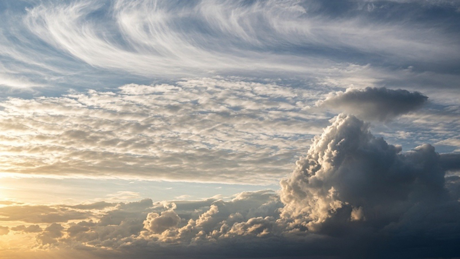
Quick answer: The World Meteorological Organization classifies clouds into ten main genera, not ten permanently fixed altitude bands. High types include cirrus, cirrocumulus and cirrostratus; mid-level types include altocumulus and altostratus; low types include stratus and stratocumulus; nimbostratus, cumulus and cumulonimbus can extend through more than one layer. Shape, cloud-base height, opacity and growth help identify the type.
Updated: 21 November 2026.
All ten cloud types at a glance
| WMO genus | Code | Typical level / development |
|---|---|---|
| Cirrus | Ci | High |
| Cirrocumulus | Cc | High |
| Cirrostratus | Cs | High |
| Altocumulus | Ac | Middle |
| Altostratus | As | Middle |
| Nimbostratus | Ns | Multi-level |
| Stratocumulus | Sc | Low |
| Stratus | St | Low |
| Cumulus | Cu | Low base, vertical growth |
| Cumulonimbus | Cb | Deep vertical |
What are the ten WMO cloud genera?
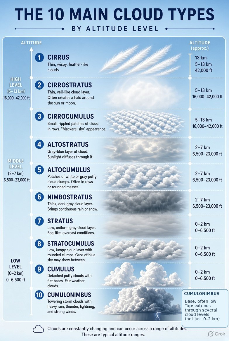
The International Cloud Atlas lists Cirrus (Ci), Cirrocumulus (Cc), Cirrostratus (Cs), Altocumulus (Ac), Altostratus (As), Nimbostratus (Ns), Stratocumulus (Sc), Stratus (St), Cumulus (Cu) and Cumulonimbus (Cb). Every observed cloud belongs to one of these genera in the main classification, and can be described further by species or supplementary features. An attractive cloud poster is helpful only if its pictures correspond to those descriptions.
List the ten WMO genera in a labelled notebook, then compare each name with a photograph from the International Cloud Atlas rather than relying only on an invented illustration. The genus is the primary classification; optional descriptions such as species, variety and supplementary feature provide further detail. For example, not every rounded cloud patch should automatically be called altocumulus without considering its apparent element size and level.
High clouds: cirrus, cirrocumulus and cirrostratus
Cirrus often appears as thin wisps or feathers. Cirrocumulus can look like tiny grains or ripples, usually without significant shading. Cirrostratus is a widespread transparent ice-crystal veil that can produce a halo around the Sun or Moon. These are typically high-cloud groups, but actual heights depend on climate zone and local atmospheric conditions. A halo is a useful clue, not a guarantee that the whole sky is one particular cloud genus.
Fine cirrus filaments are often composed predominantly of ice crystals. Cirrostratus can be thin enough to make a 22-degree halo visible, but halo visibility depends on crystal shapes, alignment and lighting. A high white veil is not always cirrostratus. Look for whether the sky has a uniform transparent layer or separate wisps and whether the Sun remains clearly visible through it. Nearby cirrocumulus can add a delicate rippled texture.
Middle clouds: altocumulus and altostratus
Altocumulus can form rounded patches, rolls or layers with larger elements than typical cirrocumulus; some parts have shading. Altostratus is commonly a greyish or bluish sheet through which the Sun may appear dim or like frosted glass. Layer thickness varies. Mid-level labels refer to typical cloud base in a broad atmospheric zone, not a universal fixed ceiling. A simple chart that gives each cloud one exact altitude everywhere creates false precision.
Altocumulus elements commonly show shading and appear larger than the tiny grains of cirrocumulus, though perspective complicates the distinction. Altostratus can form a broad grey or bluish sheet that diffuses sunlight. A beginner might confuse a thick altostratus layer with nimbostratus. Precipitation pattern and continuity of the layer offer additional clues. Taking several photos over an hour can help distinguish a moving cloud deck from an isolated patch.
Low clouds: stratus and stratocumulus
Stratus usually forms a low relatively uniform layer, sometimes like lifted fog, and can produce fine drizzle. Stratocumulus contains broader rounded elements in sheets or patches, with distinct darker shading. Similar grey skies can fool an observer when the base is not visible. Cloud elements, texture and brightness differences help. A photograph taken from ground level can hide structures that would be obvious from an aircraft or a time-lapse.
Stratus can resemble fog that has lifted above the ground and may create a dull, nearly featureless low ceiling. Stratocumulus is often more textured, with rounded masses separated by darker gaps. Both can dominate a city skyline without severe weather. Urban haze and smoke may further reduce contrast in photographs, so colour alone is not a reliable diagnostic feature. Consider visibility and how far the layer extends.
Nimbostratus: extensive rain and snow cloud
Nimbostratus is a broad often dark or featureless layer associated with widespread precipitation. It can occupy a substantial vertical extent and should not be placed rigidly inside the ‘middle cloud only’ box. Rain or snow may obscure the cloud base. Unlike a typical cumulonimbus, nimbostratus is not primarily defined by towering convective structures and an anvil shape. But rain by itself cannot prove a genus, since other clouds also produce precipitation.
Nimbostratus commonly produces widespread sustained precipitation and can obscure its own base with rain or snow below it. The thickness of the layer matters more than an exact altitude label. It is not interchangeable with a tall convective thunderstorm cloud. A sky may transition between cloud types as a weather system evolves, so a single image can represent only one point in the process. Record rain duration and cloud texture if possible.
Cumulus and cumulonimbus: vertical development
Cumulus clouds are discrete heaps with fairly flat bases and dome-shaped tops; some remain fair-weather and shallow, while others grow. Cumulonimbus is a deep convective cloud that can produce thunderstorms, lightning, strong rain and occasionally hail. Its top may spread into an anvil. These clouds can grow across low, middle and high atmospheric layers, so a single-level classification understates their structure. Stay indoors and follow weather warnings during lightning; photographing a storm is not worth exposure.
A shallow cumulus cloud may have a compact cotton-like top and a flat base, while a vigorous growing cumulus can develop toward towering convection. Cumulonimbus can reach high altitudes and form an anvil where air spreads near the tropopause. A low cloud base is therefore not evidence that the whole cloud sits below two kilometres. Lightning and thunder require appropriate safety precautions; never seek an exposed viewpoint just to photograph a dramatic anvil.
Cloud altitude chart: why height ranges vary
WMO describes the troposphere in high, middle and low levels. Typical high-cloud bases in temperate regions are often above about 5 km, middle bases roughly 2–7 km, and low bases up to roughly 2 km, but tropical and polar environments can differ. These are broad observational guides, not boundaries enforced by nature. Clouds can extend above their base, overlap layers and vary by season. Label altitude as approximate and region-dependent.
Altitude references must be interpreted geographically. Tropical high-cloud layers may occur at higher absolute heights than equivalent polar cloud layers, and mountain observers can stand within a cloud that looks low from the valley. Also distinguish cloud base from cloud top: a cumulonimbus can have a low base and a very high top. The corrected poster explicitly calls out this distinction. Treat broad altitude ranges as learning aids, not measurement results.
How to identify clouds using photos and weather context
Look at the sky’s texture and whether the cloud is a continuous layer, tiny ripples, larger patches or a vertical tower. Note whether the Sun is sharply visible, weakly diffused or completely hidden. Observe how quickly the cloud changes and whether precipitation is falling. Compare the WMO photograph examples, not only the colour of a generated poster. Cloud identity is sometimes uncertain from a single cropped image, so record time, location and several angles rather than assigning a confident label from one patch.
Cloud identification improves with repeated observations. Note date, hour, weather, direction of sunlight and whether rainfall followed. Compare apparent cloud elements with WMO examples and keep uncertain classifications open rather than forcing a name. A wide-angle image can show the overall cloud field while a zoomed view reveals texture. Combining the two is more informative than a heavily processed single photograph whose colours and geometry may be altered.
Cloud types FAQs
How many main cloud types does WMO list?
Ten genera.
Is nimbostratus always a middle cloud?
No. It frequently spans layers and should not be confined to one rigid altitude band.
Which cloud forms a Sun halo?
A thin ice-crystal layer such as cirrostratus commonly supports a 22-degree halo, though identification needs context.
Which cloud is associated with thunderstorms?
Cumulonimbus is the main deep convective thunderstorm cloud.
Can cloud altitude be read from colour alone?
No. Shape, texture, base height and the local atmospheric profile matter.
Conclusion
Learn the ten WMO genera as a starting point, then refine identification from form, location and weather conditions. An illustrated chart is a teaching tool, not a precise altitude measurement or forecast.
Sources
- WMO International Cloud Atlas — Ten Genera
- WMO — Cloud Levels and Altitude
- WMO — Cloud Classification Principles
For severe weather decisions consult your national meteorological service.

















Share Your Opinion
Comments are closed on this post.